How could that be done?
There were over 70,000 trees in this wood (as I later found out) over a big area! 68 hectares is about the size of Green Park, St. James’s Park and the Buckingham Palace gardens combined. The woodland in front of me though was a lot steeper than those flat London parks!
I had the right tools by way of the power of digital mapping, some basic but accurate instruments, and a well-practised method on my side, meaning I could collect and process the data in one day. The final result would be accurate enough to value the timber within the wood.
How Do You Measure a Forest?
My method was inspired mostly by the methods outlined in the Blue Book – the bible of anyone wanting to measure a forest. Published by Forest Research in 2006, it outlines how to measure both standing and sawn timber volumes.
The premise is simple: take a variety of sample plots of the trees around the wood and extrapolate the data to reflect the forest as a whole.
Often the trees vary a lot in height and size. This can be due to a variety of factors but commonly, exposure is a big factor. Trees higher up the hill are battered by winter storms more than those growing lower down, so they grow slower. Drainage is important too. Sites that weren’t drained properly when the trees were planted will have small trees in the wetter areas – ‘check’, as the industry calls them. They often will have no useful timber in them at all.
This variation in the size of the trees is why getting a good cover of sample plots is essential. I sit in my car looking up the hill, thinking how many times I’ll have to walk up and down it to get a good spread of data.
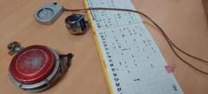
I come to my first plot location. The trees are at the bottom of the hill and are of a good size and height. I measure out a 0.01 hectare sized plot and measure the diameter of each tree within it. There are 13 trees in this plot. I choose the largest one and paint a dot on it with my can of spray paint. That’s my broadest tree and I’ll measure the top height of it. Using a clinometer and a logger’s tape I can get a value for the height of this tree. I note it down.
I walk around the wood repeating this simple method. I record where I have been on GPS, and every so often I ring my colleague to tell him I’m alright – when working alone it’s essential to check in from time to time!
I get to the top of the wood. Here I can see down the length of Loch Fyne. The trees are smaller here and I take a couple of plots to get a good spread of tree sizes.
I head back to the office, and, after some tea to warm up, have a look at the data I have collected.
Join me next time, when I consider the data I have collected and the valuation process of the woodland ready for timber harvesting.
Visit the Graduate Programme
Join the Tilhill Graduate Programme